Back مقاطعة كاتوسا (جورجيا) Arabic کاتووزا بؤلگهسی، جورجیا AZB Catoosa County, Georgia BAR Катуза (окръг, Джорджия) Bulgarian কাটোসা কাউন্টি, জর্জিয়া BPY Catoosa Gông (Georgia) CDO Катуса (гуо, Джорджи) CE Catoosa County CEB Catoosa County, Georgia Welsh Catoosa County German
Catoosa County | |
|---|---|
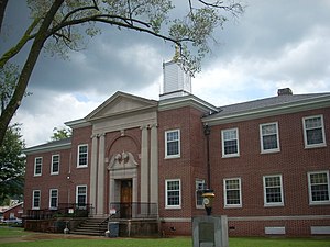
 Catoosa County Courthouse | |
 Location within the U.S. state of Georgia | |
 Georgia's location within the U.S. | |
| Coordinates: 34°54′N 85°08′W / 34.90°N 85.14°W | |
| Country | |
| State | |
| Founded | 1853 |
| Seat | Ringgold |
| Largest city | Fort Oglethorpe |
| Area | |
• Total | 162 sq mi (420 km2) |
| • Land | 162 sq mi (420 km2) |
| • Water | 0.3 sq mi (0.8 km2) 0.27% |
| Population (2020) | |
• Total | 67,872 |
| • Density | 419/sq mi (162/km2) |
| Time zone | UTC−5 (Eastern) |
| • Summer (DST) | UTC−4 (EDT) |
| Congressional district | 14th |
| Website | catoosa.com |
Catoosa County is a county in the Northwest region of the U.S. state of Georgia. According to the 2020 census, the population was 67,872.[1] The county seat is Ringgold.[2] The county was created on December 5, 1853. The meaning of the Cherokee language name "Catoosa" is obscure. "Catoosa" may come from the Cherokee words gatusi ("hill", "small mountain" or "high place") or gatu'gitse ("new settlement place").[3]
Catoosa County is part of the Chattanooga, TN–GA Metropolitan Statistical Area.
- ^ "Census - Geography Profile: Catoosa County, Georgia". United States Census Bureau. Retrieved December 26, 2022.
- ^ "Find a County". National Association of Counties. Archived from the original on May 31, 2011. Retrieved June 7, 2011.
- ^ "Catoosa County". Calhoun Times. September 1, 2004. p. 25. Retrieved April 24, 2015.

